Expedition Notes

Data Search
Search Hints
Expedition Notes |
|
||
Data Search | |||
|
|
|||
The Trip Back to TopOur intent was to collect aquatic invertebrates for phylogenetic studies from this biologically rich but under-studied region of Asia. We are keen to develop additional collaborations with colleagues interested in indentifying non-branchiopod crustaceans and sharing data. The National University of Mongolia and the Mongolian Institute of Meteorology and Hydrology invited researchers from the Crustacea Section of the Natural History Museum of Los Angeles County to collect branchiopod crustacean in 2002. Three U.S. researchers (R. Wetzer, S. Boyce, and N.D. Pentcheff) made the trip to Mongolia. Our primary goal was to collect branchiopod crustaceans from ephemeral habitats for molecular and morphological systematics research. Our secondary goal was to identify crustaceans new to science. Finding new species is likely, since this region is poorly-sampled and appears to have high endemism. The support and advice of collaborators and associates made this expedition incredibly successful. Between August 18 and September 3, 2002, we sampled 115 freshwater sites on a 3000 kilometer roundtrip journey through central and southern Mongolia. The Animals Back to TopThe target group of animals for this expedition was the "Branchiopoda". Branchiopods are a group of invertebrate animals within the larger group Crustacea. Crustaceans also include well-known animals such as crabs, shrimps, lobsters, and barnacles.
Preparing Back to Top
With the help of a tour operator experienced in U.S./Mongolia travel (Mongol Global Tours), we flew from Los Angeles to Ulaanbaatar, Mongolia, through Beijing, China. Travelers from the U.S.A. should note that although a visa is currently unnecessary to enter Mongolia, one is necessary for China, even just for a transit stop. Not knowing what to expect, we brought nearly everything we thought we might need: clothing for warm and cold weather, full camping equipment, sampling equipment, and even most of our food. We could have bought more food in Ulaanbaatar, but by having it with us, we hit the road sooner. Arriving and Setting a Course Back to TopBad weather in Beijing delayed us for several hours, but even so we were met at the airport in Ulaanbaatar by our guide and driver (Bold and Zorigt). A couple of days in the capital sufficed to finish shopping for supplies, gear up the vehicle with a roof rack, and make a propitious visit to the Gandantegchinlen Khiid (Buddhist monastery) to spin the prayer wheels. We strongly recommend this procedure: our trip went very well after doing it.
Our trip was really launched thanks to the generous and knowledgeable help provided by Khayankharvaa Terbish of the National University of Mongolia. Besides helping with permitting issues prior to our arrival, he spent time with us in Ulaanbaatar and outlined a potential route for us, based on his own biological explorations in the country. We followed his route, and it let us sample far more of Mongolia than we had ever hoped prior to the trip. Gearing Up Back to TopWe packed most of our gear into heavy-duty hinged-lid distribution boxes (from Consolidated Plastics). They proved to be relatively easy to transport and worked well in the field. The disadvantage to having it all with us, of course, was just a little bit of an overweight penalty on the air flights.
Those interested in more technical details might want to see collection techniques and logistics. The Route Taken Back to Top
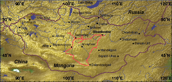
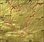
Click on the maps here for an enlarged view of Mongolia or a closer view of the track of our expedition. South to the Gobi From Ulaanbaatar Back to TopUlaanbaatar (Töv aimag), elevation ca. 1300 m, is in the north-central part of the country, on the eastern edge of Khenteyn Nuruu (mountains) in forest steppe. Heading south from Ulaanbaatar we passed through the Dundgovi' aimag (steppe), collecting north and west of Mandalgovi in ephemeral ponds. The environment becomes more arid traveling southward with the elevation at collecting sites fluctuating between 1230 - 1495 m. Between Mandalgovi and Dalandzadgad one transitions from steppe to govi (gobi) and summer temperatures rise as the elevation drops to roughly a 1000 m. In this region horses become less common as Bactrian camels become more prevalent. The Gobi and North to Bayanhongor Back to TopBypassing Dalanzadgad, we traveled west through the Gobi Altayn, Gurvan Saykhan and the Kongoryn Els, immense and beautiful sand dunes. Heading north and west we passed near Khatansuudal (Bayanlig/Tsagaan Tolgay) (Bayankhongor aimag) through the Tsagaan Uul (valley). Gently climbing from 1360 m to 1900 m elevation, we passed east of Örgön to Orog Nuur. This once-large lake was dramatically reduced to a fraction of its former size with only its easternmost edge retaining any water at all. Midday temperatures reached 32°C and the surface film had a salinity of 48 ppt. Unlike Orog Nuur, Böön Tsagaan Nuur to the northwest is a large freshwater lake. Approaching the aimag capital Bayanhongor (1745 m), one is on the south side of the Khangayn Nuruu (mountain) divide. Through the Passes to Tsetserleg and Tsagaan Nuur Back to TopClimbing up and through the Töv Gol River Valley (Tuyn Gol), we transitioned from steppe to forest steppe. The pass is at about 2700 m, with the highest peak in the region (Myangan Ugalzat Uul) at 3483 m. Descending into the now north-flowing drainage, day- and night-time temperatures were cooler and camels were been replaced by cows and yaks. Now following the Urd Tamir Gol (River) valley, we headed toward Tsetserleg (Arkhangay aimag capital). From Tsetserleg we headed to our northwestmost point of this trip, Tsagaan Nuur. East to Kharkhorin and Back to Ulaanbaatar Back to TopReturning and passing through Tsetserleg, we sampled a wide variety of freshwater habitats in this area including "lakelets", streams, ponds, and puddles. Heading towards and passing through Kharkhorin, we took a break from collecting to visit Erdene Zuu Khiid and the remains of this once expansive monastery. Making our way along the Orhon (Orkhon) Gol (River) valley, we visited the Orkhon (Orhon) Waterfall before heading north to Ögiy (Ogii) Nuur (Lake). From there we returned to Ulaanbaatar. We made a final short excursion to the eastern suburbs and Gorkhi-Tertelj to collect our last samples before packing up and heading home. Curating the Collection Back to TopProper care for the specimens we collected and wide dissemination of the collection data make the expedition valuable to the scientific community.
Those interested in more technical details might want to see collection techniques and logistics. Disseminating the Data Back to TopJust as important as preserving the physical specimens is disseminating the textual and photographic information we collected. Unless specialists around the world know these specimens exist, they won't be able to use them. Hence, this web site is an integral part of making the Mongolian expedition a scientifically useful endeavor. More detail about data dissemination can be found in the section on collection techniques and logistics. |
|
||
Comments or questions?
|
This project supported by grants DEB-BE:0120635 and DEB-PEET:9978193 from the National Science Foundation 
|
|
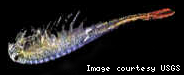 Most branchiopods live in fresh water (though there are marine and
brackish species), and often have an encysting stage that enables them
to persist in small temporary bodies of water. Groups within the
Branchiopoda include the Anostraca (brine shrimp, illustrated in the
photograph), Notostraca (tadpole shrimp), Chonchostraca (clam shrimp),
and Cladocera (water fleas). Most branchiopods are less than one
centimeter in length.
Most branchiopods live in fresh water (though there are marine and
brackish species), and often have an encysting stage that enables them
to persist in small temporary bodies of water. Groups within the
Branchiopoda include the Anostraca (brine shrimp, illustrated in the
photograph), Notostraca (tadpole shrimp), Chonchostraca (clam shrimp),
and Cladocera (water fleas). Most branchiopods are less than one
centimeter in length.